Leverage the Power of the ONEGEO API
Seamlessly integrate our data into your projects using the API and get clean data, clear lines, and solid support, every time.
Get started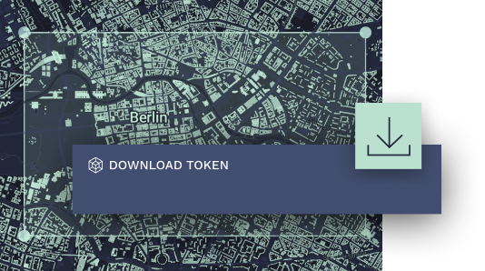
Here's what you get …
Boost Your Productivity with Automated Access
Save time and get the data you need anytime, anywhere, and on any device with automated, standardized access.
Streamline Integration for Seamless Data Use
Enjoy quick and easy integration with your existing data infrastructure, so you know it'll all work together smoothly.
Empower your developers
Our API is trusted by developers for its attribute-rich and accurate building footprints in GeoJSON, with solid support when you need it.
Unlock the Full Potential of 3D Building Data
Precise, data-driven insights can transform your risk analysis, communications planning, and 3D context models.
Optimize Your Project with 3D Data Analysis
Superior attributes, precise polygons and advanced geospatial data help you achieve powerful 3D rendering and analysis.
Enhance Collaboration and Communication
Give your stakeholders a more immersive and interactive experiences to improve collaboration and communication.
… and what you can do with it
Leverage the real value of data through analysis, whether it's for urban planning and design, risk assessment, propagation analysis and simulation, business insights, or communication and marketing.

Propagation analyses
Gain access to precise radio wave propagation for more efficient communications planning. Quickly and seamlessly view mapping simulations in real time and create more accurate and appealing maps.
Risk analysis
Use our mapping tools to generate precise risk analyses for your projects. We leverage advanced geospatial data, allowing you to access more accurate building and location data for improved risk assessments.
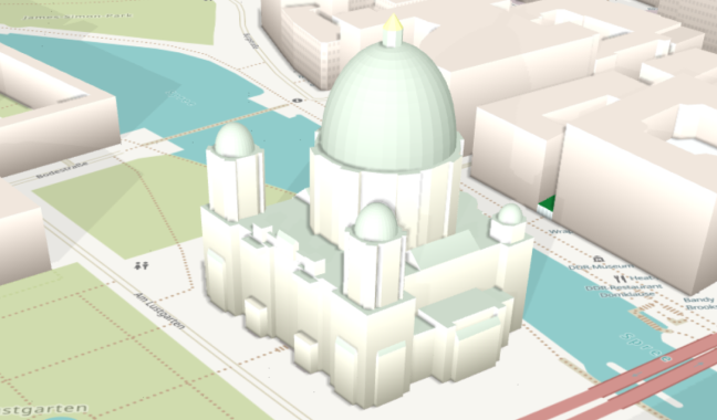
3d models
Create better 3D visuals and 3D context models for a wide range of applications. From urban planning to geo-visualization or marketing, our data lets you view locations of interest for enhanced planning and design.
Using Data to
Power Projects
Time is money, right? And you don't want to waste it searching the vastness of the web for the right data. Nor do you have to, because we already have! And now we offer you a way to quickly acquire our advanced data so you can apply it to your projects — and bring your creative vision to life.
Download
Bounding box queries let you download features of a particular area. Our API can handle data requests in the following format:
curl -o "philly.json" "https://data.onegeo.co/api/?token=ONEGEO_API_KEY&bbox=-75.25750,39.90128,-75.10153,40.01280"
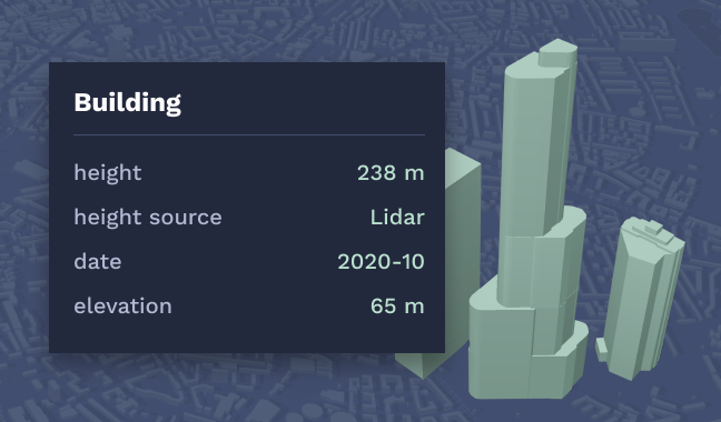
Building details
Get all information for a specific building. Our API can handle feature requests in this format:
curl -o "sphere.json" "https://data.onegeo.co/api/?token=ONEGEO_API_KEY&feature=037111f-0b9e666-6c"
Search
Search for countries, cities, states and other places. You will not only get the location back but also a set of buildings related statistics. This is the request format:
curl -o "search.json" "https://data.onegeo.co/search/?token=ONEGEO_API_KEY&query=berlin"
Our pricing plans
Get exactly what you need to enhance your projects with building data without the frills that add unnecessary expense.
Start Up
For small organisations with growing demand
- 5 000 Buildings
- Regular Updates
- Commercial Use
- 99.9% Availability
- Cancel anytime
Business
For businesses with moderate request volume
- 50 000 Buildings
- Regular Updates
- Commercial Use
- 99.9% Availability
- Cancel anytime
Enterprise
For large organisations with specific requirements
- 500 000 Buildings
- Regular Updates
- Commercial Use
- 99.9% Availability
- Cancel anytime
Do you have different requirements for volume, accounting, support?
Get in touch with our team.